Status 2024
1 Project’s objectives
In the period 2022 – 2024, the international SmartPol format of specialists from four University and Research Centers and two commercial companies, developed a project financed by the MarTERA program dedicated to marine technologies, as well as the development of the “Blue Economy”.
SMARTPOL aims to present a new and compact architecture of pollution detection, monitoring and analysis systems by integrating different types of sensors (e.g. remote sensing, IoT integrated with UAVs and USVs), developing the marine pollution detection algorithm using the data sensors and state-of-the-art technologies of intelligent systems, including image processing based on artificial intelligence.
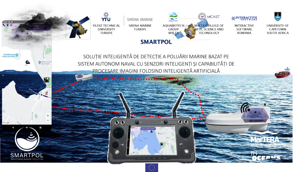 Fig 1 – Project vision – pollution detection by satellite images and verification by USV
The SmartPol project aimed to provide a pragmatic solution for pollution detection by analyzing satellite images available under open geosatellite resource sharing programs and a convenient way to verify the results on the “ground” by sending a craft equipped with specialized sensors to confirm pollution in marine waters.
The aim was to produce technological solutions for the detection of marine pollution starting from public EU satellite image resources, by processing using AI and verifying it through a naval platform equipped with specific sensors.
Consortium members joined their efforts and proposed and realized a set of mechanisms and prototype products to approach the detection of marine pollution. The development of the know-how needed to detect marine pollution using satellite images, interpreted through AI algorithms, was pursued within the consortium. For the “field” verification of the degree of pollution, the consortium aimed to develop a platform for acquiring data from marine sensors and communicating with them remotely, which could be installed on a manual or remotely controlled vessel.
2 Results
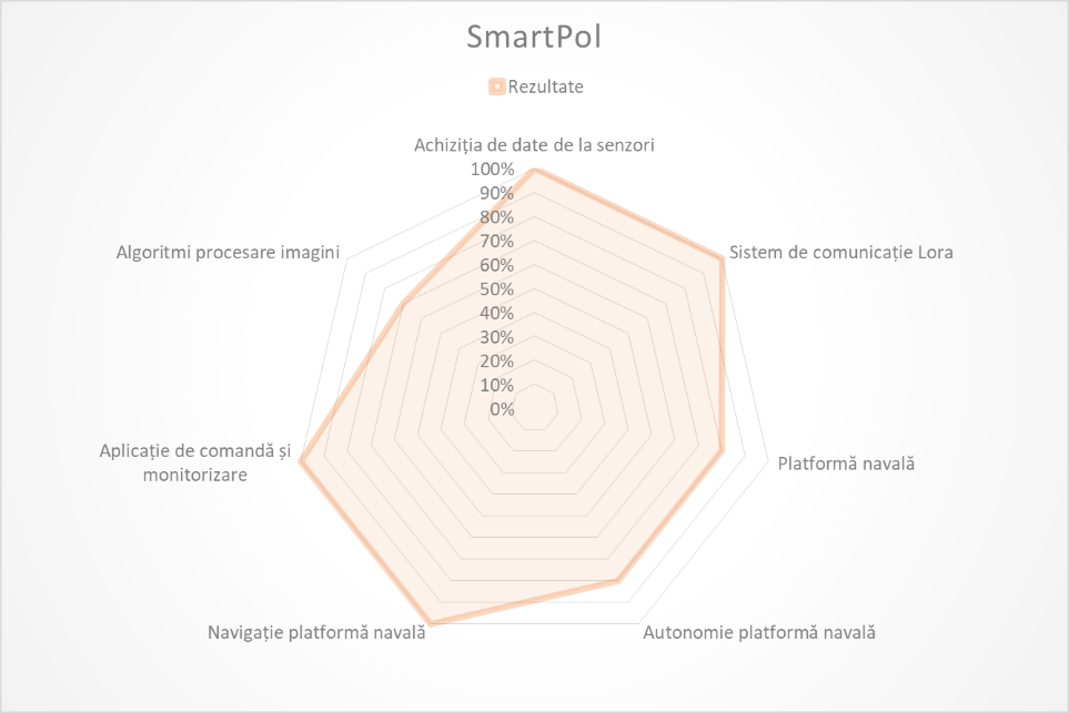
SMARTPOL is a project delivered within an international consortium with diverse members with expertise in a wide spectrum of activities. A series of results are an integral part of the project, thus:
- Novel and compact architecture based on hardware and software for marine pollution detection, monitoring and analysis
- The objective has been achieved and is documented in the project deliverables: design and execution plans, experimental modules, documentation;
- It represents the essence of the project, which allows anyone to replicate the project in their field of activity;
- Coastal coordination center and autonomous vessel, equipped with multi-sensor technologies and artificial intelligence
- The objective was achieved and available in the Istanbul demo site;
- It represents the practical way of centralizing the data obtained by using the elements of the project;
- Integration of several types of pollution sensors
- The objective has been achieved and is supported by a functional pollutant monitoring mechanism, but also laboratory testing procedures (Malta) (for the detection of microplastics);
- It represents the configurations of sensors needed to detect various categories of pollution;
- Development of algorithms for the assessment of marine pollution, including those based on artificial intelligence
- The objective is partially achieved (December 2024, Turkey), with consistent results regarding the processing of satellite images; however, the quality of satellite images from public sources still does not allow automatic detection of pollution with certainty;
- Represents the suite of working procedures on satellite imagery, using various dedicated algorithms, including AI for the detection of polluted marine areas;
- Autonomous navigation system and communication system
- The objective is achieved through the construction of a catamaran-type naval assembly by the partner Sirena Marine (Turkey) and equipped with a communication system designed by Interactive Software (Romania)
- Represents the model naval assembly on which the pollution detection sensor structure is installed;
- The naval platform is being built by the Turkish partner, Sirena Marine;
- The naval platform is equipped with the acquisition and communication assembly designed by ISW.
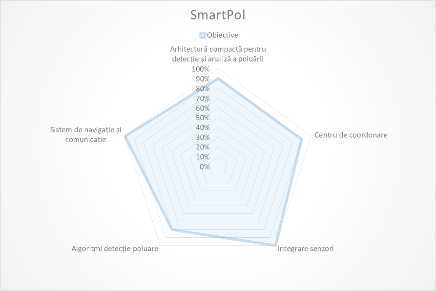 Fig 2 – Graphic representation of SmartPol results
The architecture of the developed solution is open, using as many components as possible accessible to any organization interested in reproducing the functional assembly, and the hardware and software elements to be published under an open license.
Activities have been carried out (YTU, Turkey) on how satellite images from open resources (Copernicus) can be used to identify pollution in marine waters and determine the degree of pollution. Image processing techniques were used and artificial intelligence algorithms were trained. The partner Sirena Marine (Turkey) designed and built in its own factory a catamaran type vessel, which was later equipped with the specific propulsion and navigation systems and which was designed in such a way that it could also include various categories of payload, including the necessary sensors for pollution checking, data acquisition assembly and data communication between sensors and data center.
Interactive Software (ISW, Romania) created an assembly for the acquisition of data from the sensors for the determination of pollution and an assembly for the communication of data from the measurement site to the coordination center. The architecture proposed by ISW also addresses the configuration that is installed on the catamaran.
The Maltese partners (MCAST and AQUABIOTECH) have identified sensor categories suitable for pollution detection and developed a mechanism for detecting microplastics in water under laboratory conditions. The recommended sensors are integrated into the overall SmartPol architecture.
The University of Cape Town (South Africa) designed and built its own electronic module for data acquisition from the same categories of pollution detection sensors as those recommended in the consortium. The developed assembly is integrable in the general SmartPol architecture, compatible with the naval platform built in Turkey and integrable in the data communication system built by Interactive Software.
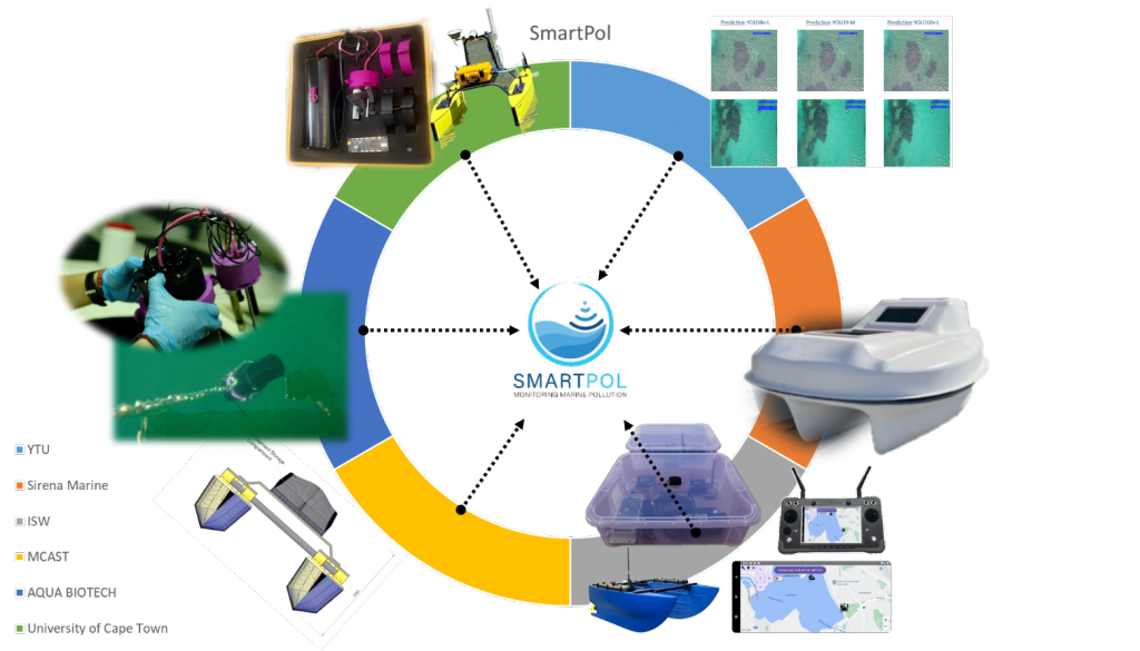
Fig 3 – Consortium member participations and integration into the SmartPol solution
The above results represent aggregations at the level of the entire consortium, and the achievement of these results followed a series of joint activities and individual contributions at the level of each individual member, the final solution being a documented set of members’ contributions.
During the course of the project, the members of the consortium achieved several individual objectives, prior to the final results. Thus:
- Sirena Marine, Turkey has designed and developed a new catamaran-type naval platform capable of supporting a marine pollution data acquisition ensemble;

- The naval platform also integrates the architecture of the data acquisition and communications system, developed by the Romanian partner;
- YTU, Turkey produced mechanisms for analyzing satellite images from public sources to highlight marine areas potentially affected by pollution;
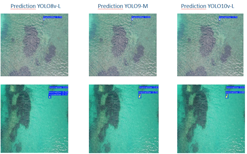
- They are an integral part of the project results;
- MCAST, Malta has developed procedures for the detection of microplastics in water;
- They are an integral part of the project results;
- AQUABIOTECH, Malta provided the testing infrastructure for the sensors required for pollution detection;
- INTERACTIVE SOFTWARE, Romania developed a data acquisition system from sensors and a communication system between the naval platform and the shore;
- The architecture of the developed system is also applied to the naval platform of the partner in Turkey;

- For the tests, a laboratory-type infrastructure similar to the one in Turkey was created, comprising a separate naval platform capable of supporting the assembly developed by ISW;
- The architecture of the developed system is also applied to the naval platform of the partner in Turkey;
- The University of Capetown, South Africa has developed a compact, independent data acquisition system;

- It can be integrated into the communication system developed by the Romanian partner;
3 Exploitation of the results
The items resulting from the SmartPol project are design and execution documents, models and prototypes, which can be used by organizations that want to carry out similar actions in the area of marine pollution detection or to expand the research area of the project.
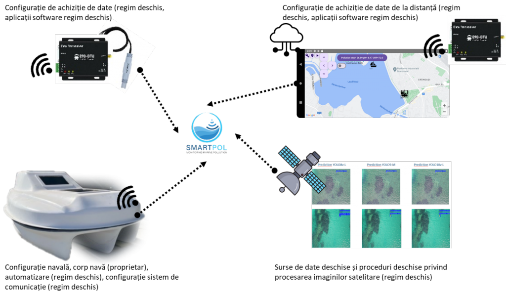 Fig 4 – Functional components of the SmartPol project
The results of the project address several systemic components of the developed assembly:
- Configuration of data acquisition from pollution sensors, including remote communication assembly;
- Module for acquisition of data from sensors
- Modules for Lora communication (between the naval platform and the coordination center)
- The naval configuration, the carrier of the data acquisition assembly, which also includes the dedicated communication assembly, for navigation;
- Naval platform, equipped with autonomy and remotely controlled navigation
- The configuration in the command center, which performs the monitoring of the naval assembly;
- Functional assembly command and monitoring application
- Configuration in the command center covering the processing of satellite images from open sources through specific algorithms, including AI
- Pollution assessment procedures on satellite images
- Pollution assessment procedures on satellite images
Fig 5 – Graphic representation of SmartPol results
Within the consortium it was agreed that the results of the project will be available in an open regime to the general public, accompanied by instructions and examples for easy integration into other projects, products and services. The hardware components are accompanied by technical projects in open hardware mode, the developed software components are available in open source mode, and the operational procedures for image and data processing are described in documents, also in open mode.
ISW was directly responsible for the sensor acquisition module, the communication system between the acquisition module and the data center using Lora technology and the implementation of the command and control application. ISW designed, developed and commissioned all elements undertaken.
The data acquisition and communication component has two important modules.
The acquisition module from the sensors is an independent hardware and software assembly, with energy autonomy designed and developed for taking measurements of pollution parameters. The assembly also contains a GPS receiver for obtaining the georeferenced location where the measurements are made.
The Lora communication module is a hardware and software assembly that works alongside the acquisition module, is powered by the same energy source, and is designed and developed for remote transmission of data on pollution and geographic position of measurements.
The Lora communication module has a part that installs on the platform that performs the measurements (it can be a boat or a naval drone) and a part that installs on the shore, from where the whole assembly is operated.
The built-in command and control application allows monitoring the status of the acquisition platform, retrieving pollution data, planning a travel route and commanding navigation.
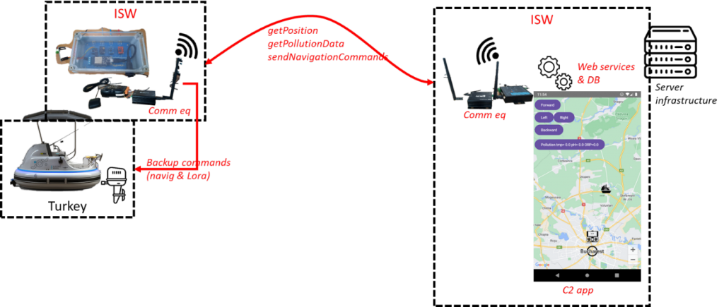 Fig 6 – Integration of functional elements (ISW)

Fig 7 – Integration of USV control equipment and communications, concept (left) and prototype (right)
Processing and communication equipment are:
- Server serial
- GPS
- Pollution sensor kit
- Lora radio relay a
- Power kit
The solution was designed from the start to also operate independently in the absence of the USV naval platform.
Software development for data acquisition, encapsulation in open data structures and storage was implemented using C/C++ programming languages. Data storage is done in Firebase (Google) structures.
The remote communication elements between the USV component and the data center is addressed in Lora technology according to the scheme below and is documented in the project documents.
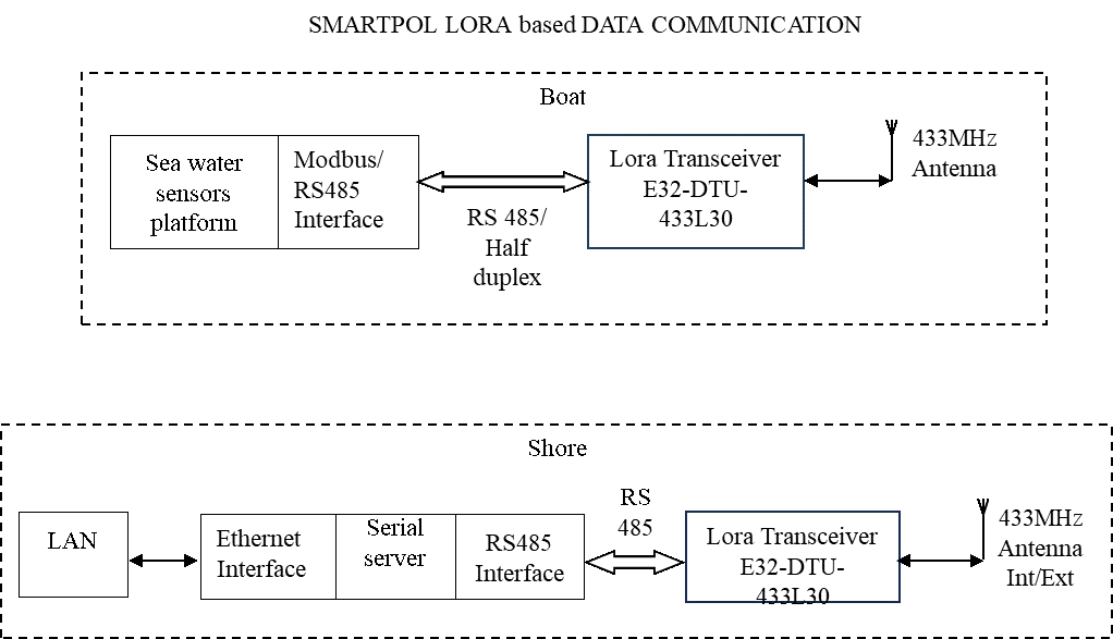
Fig 8 Communications infrastructure
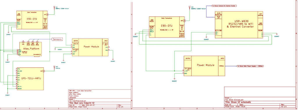
Fig 9 Architecture of USV (left) and shore (right) electrical connections
Within the project, a specific command & control application was developed that allows monitoring the pollution measurement setup, allows remote control of the naval assembly, if it exists, and saves data in a cloud database.
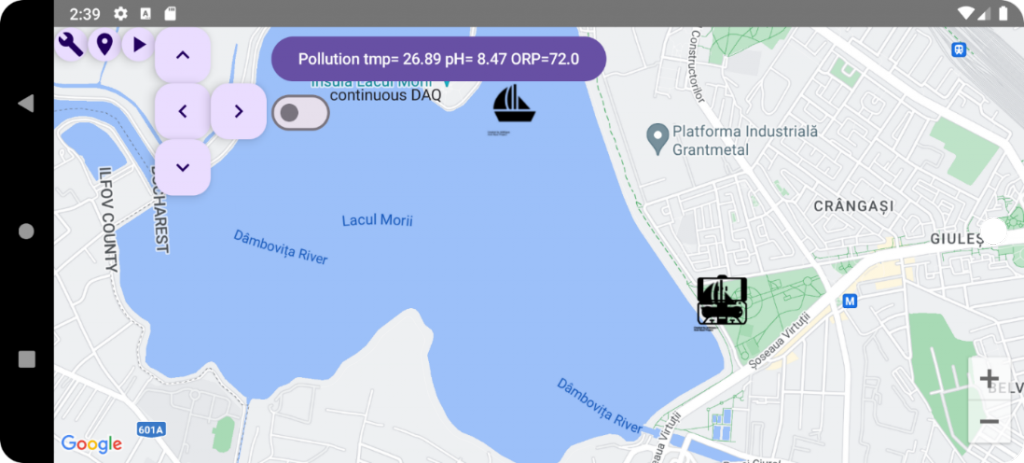
Fig 10 Graphical user interface of the command & control application
The results above, those of the whole consortium and the specific elements produced by ISW are openly available.
4 Impact of project results
The architecture developed within the project allows any organization to replicate the project results, apply them immediately and/or improve and extend the concept to diverse research/applicability areas.
For each individual organization within the SmartPol consortium, the experience gained within the project meant practicing skills in their own field of expertise, exchanging know-how and expanding each one’s capabilities with new elements within the “blue economy” policies.
The results obtained within the project prove to be useful from a scientific point of view through the existence of a fast mechanism for the detection of pollution, a set of hardware and software architectures for the construction of a platform for data acquisition and remote communication, working procedures on the detection of micro-plastics , working procedures regarding the detection of pollution through the processing of satellite images. In terms of commercial potential, at the level of the entire consortium we also have a consistent result: new, functional, large-caliber naval platform that can be adapted for a wide range of activities.
To validate the architecture of the solution system generated as a result of the project activities, each member of the consortium made equivalent laboratory-type setups for directly coordinated assemblies and modules. In this way, the results of the research and development activities allowed the identification of the best solutions and exploratory alternatives for the studied issue.
Except for the design of the naval component made by the partner in Turkey, which is covered by commercial patents, all other results of the project are available in the open regime.
The SmartPol project lays the foundations for effective and sustainable water quality monitoring mechanisms using naval platforms, but also opens up opportunities for new applications.
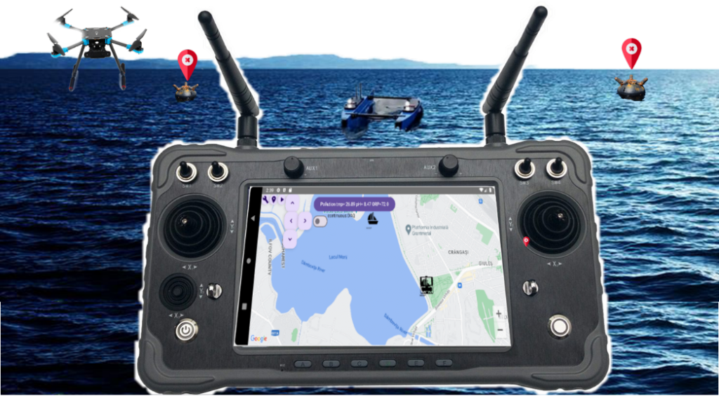
Fig 11 – Potential future projects starting from the SmartPol experience
As part of the activities carried out, apart from the aspects that directly supported the success of the project, by achieving the assumed results, we also studied the possibility of transmitting video streams through the Lora infrastructure, and in the future we are considering merging the video images taken from aerial drones with the measurements made with marine drones. ISW aims to expand the experience and equipment developed within the project through initiatives and applications that address topics of interest in its field of activity, such as the detection of marine threats or the synchronization of elements detected by USV (marine) with those from UAVs (air).
During the course of the project, apart from the specific activities of analysis, design, development, testing and subsequent refinements of the resulting intermediate products, including assistance within the consortium for the distribution of the obtained know-how and its integration into the efforts of each individual team, were carried out and actions to disseminate the results, testing in the natural environment and approaching partner organizations, potential collaborators in the future on complementary topics.
Presentation of the project at the international dissemination forum, of the MARTERA funding program, Brussels, 2023.
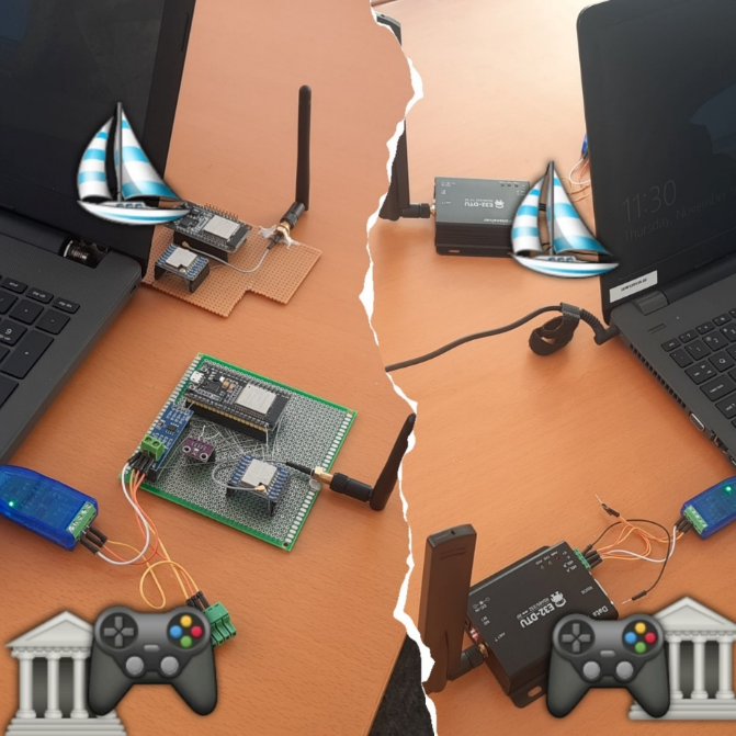
In-house investigation and research activities on data acquisition architecture, sensors and communication equipment for data transmission between measurement site and data center. The initial elements were educational equipment of the Arduino type and local Wireless, later certified educational and commercial equipment of the GPS type, serial server, Lora transceivers, professional sensors were used.
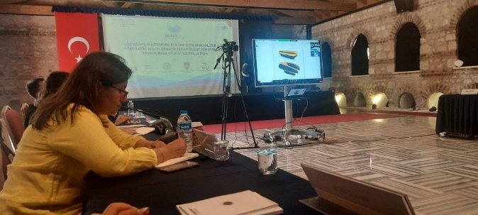
Consortium working meeting, presentation of interim results, update of action plans and harmonization of future efforts to achieve project goals, Istanbul 2023.
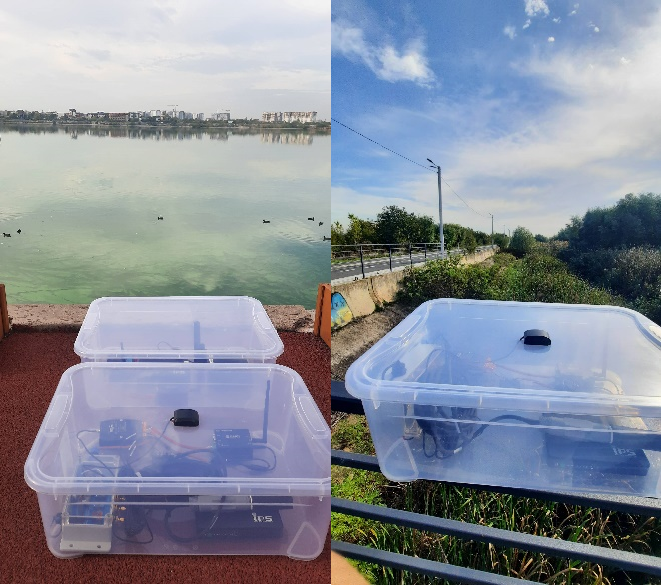
Equipment test session in the urban lake environment, Lacul Morii, Bucharest, Romania, 2024. Lora communication checks were carried out between the command center and remote locations, at the water level of the sensor platform, including checks of GPS positioning and transmission of acquired data in-app ordering and cloud saving.
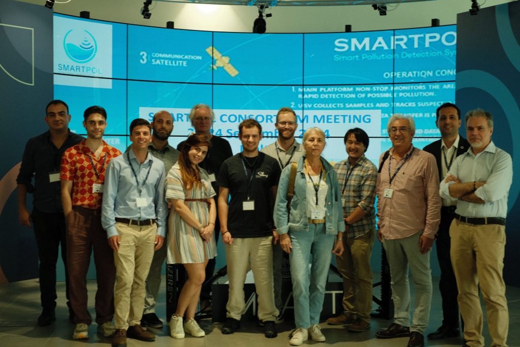
Consortium working meeting and equipment testing session, Malta, 2024.

Joint test session of equipment proposed under the architecture of the developed SmartPol solution, Malta, 2024.
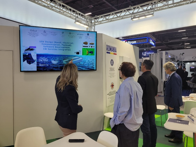
Presentation of the SmartPol project, Interactive Software’s effective contribution within the consortium and future ISW initiatives to consolidate the experience and expertise gained within the SmartPol project, Eurosatory, Paris, 2024.
The involvement in the SmartPol project gave us the opportunity to develop engineering modules and IT applications that we can also use within the company’s products and services and possible complementary applications, such as the fusion of aerial image processing and data taken from USV/UAVs for detection of marine threats (sea mines). The ISW team had the opportunity to learn about a new field – satellite image processing through AI mechanisms, collaborate on data exchange with other electronic systems, and tackle the USV field. We consider very useful the experience gained and the initiatives already started, stimulated by the SmartPol project.
